| Branches of the Baekdu-daegan |
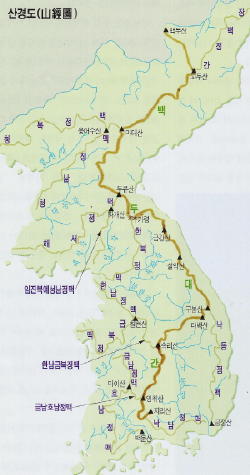
The "Baekdu-daegan" branches off into over a dozen
major earth-energy-lines that follow Korea's lesser
mountain-ranges, and many minor ones. There are
various different theories that can be found on exactly
how many branches and exactly which peaks they run
through, but there is agreement on all the main points.
Through extensive study, I have determined 14 main
branches, as listed on this page.
Most of Korea's highest peaks and roughly half of
its most-sacred mountains are found along the Baekdu-
daegan, and these branches include most of the rest of
the others. All of Korea's major rivers begin on or near
the main line, and then flow between the branches --
most of the branches are named after their relation to
those rivers (buk or nam, meaning north or south of).
I have tried to indicate the relative sacred and/or secular
importance of these various mountains by relative
font-sizes 16~24 (this does not apply to the "bypassed" peaks).
| the Major Branches of the 백두대간 are: |
6 Branches that begin in North Korea:
1. Jangbaek-jeonggan Range begins at Seolleong-
bong Peak of Godu-san, heading northeast through:
Mantap-san 2206m
Gwaesang-bong 2136m
Gwisang-bong 2333m
Tugu-bong 2335m
Gwonmo-san 2541m
Dojeong-san 2201m
Jayu-san 1669m
Songjin-san 1164m
ending at "Seosura" north of Najin City
Note: this branch has the different designation-title -jeong-gan
(instead of -jeongmaek) because it does not channel a major river
from the Baekdu-daegan entirely inside of Korea down to the ocean,
as all the others do; it is the southern range guiding the Duman-
gang [Tumen River] which originates at Baekdu-san and forms the
northeastern border of Korea with China (and Russia for 10 miles).
2a. Cheongcheon-jeongmaek Range begins
at Madae-san, heading west through:
Dongbaek-san 2096m
Sobaek-san 2184m
to Ung-eosu-san a.k.a. Nakrim-san 2014m,
where it splits into two branches:
2b. Cheongbuk-jeongmaek Range branches
off heading west through:
Daeam-san 1566m
Dongrim-san 1165m
Manpung-deok-san 1159m
Birae-bong 1470m
Cheonma-san 1169m
Hwa-am-san 620m
ending south of Shineuiju City
Note: this branch 2a and 2b not only channels the Cheongcheon-
gang River from its north, but it also, along with the first section of
the Baekdu-daegan itself, is the southern range guiding the Amnok-
gang [Yalu River] which originates at Baekdu-san and forms the
north-central and northwestern border of Korea with China.
3. Cheongnam-jeongmaek Range branches off
from Ungeosu / Nakrim-san heading SW through:
Obong-san 1500m?
Myohyang-san Biro-bong 1909m
Myohyang-san Oseon-bong ?m
Myohyang-san Beobwang-bong ?m
Yongmun-san 1180m
Gangryong-san 446m
Mandeok-san 243m
Gwangdong-san 396m
ending at Gwangryeong-jin north of Nampo City
Note: the Daedong River runs just south of this branch.
8 Branches that begin in South Korea
Part II:
9a. Hannam-geumbuk-jeongmaek Range begins at
Sogni-san's Munjang-dae Peak, heading NW through:
Sogni-san Gwaneum-bong 985m
Sogni-san Myo-bong 874m
Geumdan-san 767m
Shinseong-bong 630m
Mideung-san 558m
Guksa-bong 588m
Seondu-san 527m
Seondo-san 547m
Joigu-san 657m
Bohyeon-san / Buyong-san 644m
Deokseong-san 520m
Chilhyeon-san 516m
Chiljang-san 492m
9b. Hannam-jeongmaek Range begins at
Chilhyeon-san and then heads northwest through:
30 km various hills of Yongin County
Kwanggyo-san 582m
Gyeyang-san 395m
Gahyeon-san 215m
Tae-san 135m
Munsu-san 376m (south of the mouth of the Han River)
Goryeo-san 436m (northern Ganghwa Island)
Hyeolgu-san 466m (central Ganghwa Island)
Toimo-san 339m (central Ganghwa Island)
Jingang-san 443m (central Ganghwa Island)
Jeongjuk-san 200m (southern Ganghwa Island)
Mani-san 469m (southern Ganghwa Island)
ending at Sang-bong 255m, by the Yellow Sea
10. Geumbuk-jeongmaek Range begins at
Chilhyeon-san and then heads southwest through:
Deokseong-san 521m
Seo-un-san 574m
(nameless) 459m
(nameless) 524m
Seonggeo-san 579m
Taejo-san 422m
Gyeongeom-san 321m
Goryeo-san 307m
Biryong-san 248m
Guksa-bong 403m (turns NW)
Bongsu-san 364m
Gwangdeok-san 646m
Bongsu-san 535m
Cheonbang-san 479m
Myeong-u-san 368m
Janghak-san 381m
Bae-ani-san 186m (turns south)
Baekwol-san 418m
Beob-san 459m
Munbak-san 338m
Cheonma-bong 422m
(Chilgap-san 561m is bypassed)
Baekwol-san 560m (turns north)
(Seongtae-san 624, Munbong-san 633, Seongju-san
677 and Jogong-san 402 are bypassed)
Oseo-san 791m
Acha-san 424m
Nameless hills 14km in Hongseong-gun 100~180m
Ilwol-san 394m
Hongdong-san 310m
Deoksung-san Sudeok-bong 495m a.k.a. Sudeok-san
Deoksung-san Wonhyo-bong 480m
Deoksung-san Gaya-bong 678m (turns west)
Deoksung-san Seokmun-bong 653m
Deoksung-san Ilrak-bong 521m
Deoksung-san Nameless 271m & 183m
(13 km through southern Seosan City)
Jeonggeum-san 203m
Pyeongpung-san 176m
Geumgang-san 316m
Ending at Palbong-san 362m (near the Yellow Sea Coast)
(note: much of this is the lower part of what more conventional
geography of Korea calls the Charyeong Range)
11. Yeongdong-jeongmaek Range begins at
Daedeok-san and heads south then NE through:
(long ridge going south)
Hoindaemi-san 1018m
Sudo-san 1316m
Danji-bong 1327m
Jakil-gok-bong 1258m
Duri-bong 1133m
Gaya-san 1430m
Hyeongje-bong 1022m
Dokyong-san 956m
Yeomsok-san 970m
Dodang-san 597m
Baekma-san 716m
Yeongam-san 782m
ending at Geumo-san 977m (by the Nakdong River)
(although it could be thought to jump over the river,
running through Supdaemi-san 519m
Yuhak-san 839m
Ogae-san 467m
Ga-san 902m
Pagye-bong 991m
ending at the highly-sacred Palgong-san 1192m)
12a. Geumnam-honam-jeongmaek Range begins
at Yeongchwi-san and then heads northwest to:
Jangan-san 1237m
Bonghwa-san 786m
Seongsu-san 1059m
Ma-i-san 618m
12b. Geumnam-jeongmaek Range splits off
from Ma-i-san and heads north through:
Bugwi-san 806m
Unjang-san 1126m
Wangsa-bong 718m
Seonnyeo-bong 666m
Cheondeung-san 707m
Daedun-san 878m
Wolseong-bong 650m
Barang-san 555m
Gitdae-bong 393m
Hambak-bong 404m
Gaetae-san 360m (a.k.a. Cheonho-bong)
Guksa-bong 437m
Hyangjeok-san 574m
Gyeryong-san 878m (turns west)
across 30 km of hills & ridges
to finish at Buyeo Town's Nakhwa-am
13. Honam-jeongmaek Range splits off from
Ma-i-san and then loops down all thru
South Jeolla Province, passing through:
Naedong-san 887m
Eungbong-san 609m
Woltong-san 604m
Hoimu-san 830m
Gitdae-bong 644m
Naejang-san Janggun-bong (E) 606m
Naejang-san Janggun-bong (W) 763m
Naejang-san Yeonja-bong 673m
Naejang-san Shinseon-bong 763m
Naejang-san Sangwang-bong 741m
Naejang-san Baekam-bong 741m
(note: this part so far is the mid-section of what more
conventional geography of Korea calls the Noryeong Range)
Daegak-san 528m
Janggun-bong 558m
Bulda-san 685m
Mudeung-san 1187m
Yongdu-san 514m
Jonjae-san 704m
Jogye-san 884m
Bongdu-san 753m
Wolchul-bong 768m
Dosol-bong 1123m
finishing at Baekun-san 1218m (south of Jiri-san)
14. Naknam-jeongmaek Range begins at Jiri-san
Yeongshin-bong (1652m) and heads south
then east through:
Samshin-bong 1284m
(a sub-branch continues south thru Shiru-bong
1100m, Hyeongje-bong 1115m, Shinseon-bong
600m and Mae-bong 865m to Baekun-san 1218m)
Ju-san 831m
Hoindam-san 645m
Sarim-san 574m
Ok-san 614m
Imyeong-san 570m
Shilbong-san 185m
Museon-san 278m
Bongdae-san 409m
Yeonhwa-san 528m (turns northeast)
Gitdae-bong 521m
Yeohwang-san 744m (turns east)
Seobuk-san 739m
Gwangryeo-san 720m
Muhak-san 761m
Cheonju-san 640m
Guryong-san 432m
Jeongbyeong-san 567m
Eungbong-san 283m
Mureung-san 312m
Mujeok-san 700m
Seokryong-san 493m
Shineo-san 630m (aka "Bunseom-san"?)
ending at Dongshineo-san 476m
(right across the end of the Nakdong River from
the very sacred Geumjong-san of Busan City)
8 Branches that begin in South Korea
Part I:
7. Han-gang Gi-maek Range begins at Odae-san
Duro-bong, heading south-then-west through:
Odae-san Sangwang-bong 1491m (Buk-dae)
Odae-san Biro-bong 1563m (Jung-dae)
(Odae-san Sodae-bong 1421m is bypassed)
Odae-san Horyeong-bong 1560m (Seo-dae)
Gyebang-san 1577m
(So-gyebang-san 1490m is bypassed)
Hoiryeong-bong 1331m
Heungjeong-san 1277m
Cheongryang-bong ~1200m
Baekjeok-san 1141m
Taegi-san Samgye-bong 1259m
(here, the Baekdeok-Jimaek branches south to Saja-san 1180m,
Baekdeok-san 1350m and beyond; and the Yeongwol-Jimaek
branches south to Chiak-san 1288m, Baekun-san 1086m,
Gamak-bong 886m, ending at Taehwa-san 1027m)
Bongbok-san 1031m
Unmu-san 980m
Suri-bong 960m
Daehak-san 876m
Deokgu-san 656m
Eunggok-san 603m
Mandae-san 679m
O-eum-san 930m
Geummul-san 774m
Shiru-bong 502m
Galgi-san 685m
Do-il-bong 864m
Yongmun-san 1157m
Yumyeong-san 861m
Soguni-san 798m
Cheonggye-san 656m
Nojeok-bong 231m
Finishes at North Han River, at confluence with South Han)
(note: this is the upper part of what more conventional
geography of Korea calls the Charyeong Range. It is called
a Jimaek instead of Jeongmaek because it only divides the
North and South Branches of the Han River, and it doesn't
reach the coast.)
Primary SOURCES for these listings:
1. Shiljeon Baekdudaegan Jongju Sanhaeng, a
book by Bang Sang-hoon, published by Choson-
ilbo-sa (the Seoul newspaper company) in 1997
2. Daehan-minguk 2005 Map of the Korean
Peninsula, published by Jungang Atlas, Seoul
3. Doro-jido Choishinpan Jido-daesajeon, a book
of 1:100,000 maps of South Korea, 2005 edition
by Seongji Munhwasa Publishers, Seoul.
4. Yeongjin 5-man Jido, a book of 1:50,000 maps
of South Korea, 2006 edition by Yeongjin
Munhwasa Publishers, Seoul.
These sources each contain differing information, and
contradict each other in various ways, including the
names, heights and exact locations of some peaks. I
have done my best to combine and reconcile those
differences, to make it make sense, in many hours of
focused consideration of multiple sources.
In particular, some peaks are named "-bong" [peak] on
some maps and "-san" [mountain] on others; there is also
the suffix "-dae" [platform, with a Buddhist meaning] used
for a few peaks. There doesn't seem to be any consistent
rule for which of those suffixes gets used (neither altitude
nor distance from other peaks seems to have much to do
with it), and there seems to be no consistent system for
grouping peaks together as one overall "-san"; these
seems to be only matters of common usage. When in
doubt, I have used "-san".
The mountains located in what is now North Korea pose
particular problems, as their names, precise locations and
altitudes differ on the various sources available -- we just
don't yet have very exact and reliable information.
The Republic of Korea's new Romanization system has
been used throughout, even for the North Korean
mountains, in order to match with contemporary South
Korean maps and websites, and in the interest of
consistent accuracy. I would welcome any corrections or
suggestions for improvement for these listings.
| The 18 Currently-Most Sacred Mountains on these 14 Branches: (mostly in South Korea, due to our lack of info about the North, especially modern conditions) |
|
8. Nakdong-jeongmaek Range, a.k.a. the Taebaek-
sanmaek Range's southern section, begins at Gubong-san
(just west of Maebong-san 1303m, NE of Taebaek City), then
heads south through:
Baekbyeong-san 1259m
Tosan-bong 1072m
Myeon-san 1246m
(Sangbang-san 1175m is bypassed)
Myo-bong 1168m
Satgatje-bong 1119m
(Eungbong-san 999m is bypassed)
Baekbyeong-san 1154m
(Omi-san 1071m is bypassed)
Jinjo-san 908m
Tonggo-san 1067m
Chilbo-san 974m
(Ilwol-san 1218m is bypassed)
Geumjeong-san 849m
Baekam-san 1004m
Dokgyeong-san 683m
Maengdong-san 796m
Myeongdong-san 812m
Podo-san 747m
Juwang-san Daedun-san 900m
Juwang-san Beokgu-deung 846m
Juwang-san Wanggeo-am 907m
(Juwang-san 721m is bypassed)
Juwang-san Mupo-san 717m
Jacho-san 763m
Baeteul-bong 862m
Myeonbong-san 1113m
Bohyeon-san 1124m
Giryong-san 961m
Chimgok-san 725m
Unju-san 806m
Cheonjang-san 695m
Samseong-san 589m
Eorim-san 510m
Innae-san 534m
Gwan-san 394m
Manbul-san 275m
Obong-san 634m
Saryong-san 683m
Danseok-san 827m
Goheon-san 1033m
Gaji-san 1240m
Neungdong-san 982m
Ganwol-san 1083m
Yeongchuk-san 1209m
Chuiseo-san 1081m
Shisal-deung 981m
Yeomsu-bong 816m
Cheonseong-san 922m
Geumjeong Janggun-bong 747m
Geumjeong-san 810m
Geumjeong Sanghak-bong 638m
Baekyang-san 642m
Eumgwang-san 504m
Gudeok-san 565m
Shiyak-san 523m
Seunghak-san 496m
(Cheonma-san 325m and Jinjeong-san 156m are bypassed)
Bonghwa-san 150m
Mulun-dae ?
Alternate Eastern ending:
Gubong-san (Jangsu-dae) 408m
Daecheong-gongwon Park 200m?
Minju-gongwon Park 200m?
Yongdu-san (downtown Busan) 150m?
Bongrae-san (Yeongdo Island) 395m
Taejong-san (Yeongdo Island) 250m
4a. Haeseo-Yeseong-Imjin-jeongmaek Range
begins at Duryu-san, heading SW through:
Gasa-san 1361m to Hwagye-san 1041m a.k.a. Myeong-
jideok, where it splits into two branches:
4b. Haeseo-jeongmaek Range splits off
running west through:
Daejak-san 1277m
Eonjin-san 1120m
Cheonja-san 756m (turns SW)
Myeolak-san 816m
Unbong-san 600m
Bulta-san 608m
ending at Jang-san 200m on the Yellow Sea coast
5. Yeseongnam-Imjinbuk-jeongmaek Range
splits off from Hwagye-san, running SW through:
Hakbong-san 664m
Sudong-san 717m
Cheonma-san 762m
Songak-san 488m (of Gaeseong City)
finishing at Jinbong-san 310m (mouth of the Han River)
6. Hanbuk-jeongmaek Range begins at either
Baekam-san Nam-bong or Shikgae-san, heading
south then west through:
Jeokgeun-san 1073m (in DMZ)
Daeseong-san 1175m (near DMZ)
Bukkye--san 1057m
Bukju-san 1152m
Gwangdeok-san 1046m
Baekun-san 904m
(Hwa-ak-san 1468m /1436m / 1153m are bypassed)
Gukmang-bong 1168m
Gangssi-bong 830m
(Myeongji-san 1267m is bypassed)
Cheonggye-san 849m
Hyeondeung-san 936m (a.k.a. Unak-san)
Guksa-bong 547m
Jukyeom-san 601m
Yongam-san 477m
Gitdae-bong 288m (long ridge going SW)
Surak-san 638m (turns west)
(Bulam-san 507m is bypassed)
Dobong-san Seonin-bong 740m (part of Bukhan-san)
(Dobong's O-bong 660m & Sapae-san 552m are bypassed)
Dobong's Sangjang-bong 543m
(the Samgak-san 837m complex is bypassed)
Nogo-san 496m (long ridge turns north)
Gyemyeong-san 559m (turns west)
Bakdal-san Dong-bong 350m
Bakdal-san Seo-bong 277m
Majang-san 100m?
Gigan-san 246m
ending at Jangmyeon-san / Bohyeon-san 168m
(where the Imjin River runs into the Han River)
(just below that is Tong-il-dongsan Park, with a 151m
peak and Odu-san 100m? right next to the confluence)
| New! Baekdu-daegan Trail Guidebook "Hiking Korea’s Mountain Spine" By Roger Shepherd and Andrew Douch, with David A. Mason is finally available for hikers and cultural-explorers! Reviews, Interviews and Comments on the Guidebook |